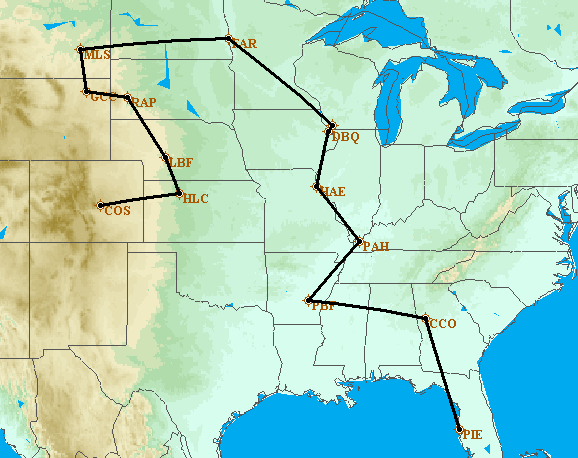
Start with the plan below, or go directly to the actual route.
Each year, the
Cirrus Owners and Pilots
Association
(COPA) hosts a conference (Migration) for the benefit of their
members. In the past, I have flown to Duluth, MN, a number of times, and
to Dayton, OH, for these
parties conferences. This year the Migration is in
Colorado Springs, CO, home of the
USAF Academy. I have a chance to fly to
quite a few states that I have never flown over, or landed in, before, so I'm setting my route to
maximize the number of states I have landed in. Additionally, I think it
would be pretty cool to follow the path of the Mississippi River from AR/MS all
the way up into Minnesota, so I'm planning to do that. And I hope to be
able to fly over Devil's Tower in WY and Mt. Rushmore in SD. My initial plan looks like
this.
8/6/11 - As planned, I flew to Palmetto, GA, 20 miles southwest of Atlanta, to visit with Kristie, Kristoffer and baby Isabelle. The area is served by at least 2 airports - FFC and CCO. I've flown to Falcon Field in Peachtree City a number of times, so this time I elected to try Newnan-Coweta County Airport in Newnan. It is less busy, and a little cheaper then FFC, and a nice field. Kristie picked me up and we had a grand time. Leaving St. Petersburg, my instruments showed an outside air temperature of 93F. After climbing to 8,000 feet, the same gauge showed 66F, a nice cool breeze in the cockpit.
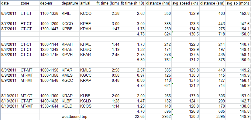
8/7/11 - We awoke to rain and a low overcast, so I knew I wouldn't be leaving on time. The rain continued for a couple of hours, and just looking up the sky cover appeared too low for me, so I waited and watched the radar pictures. After a while, on a recon mission outside, I saw a Delta big-jet departing from ATL, at what I estimated as 5,000 or 6,000 feet, so I decided to get on my way to Pine Bluff, AR. The departure weather had calm winds, a 10 mile visibility, and a clear sky, although the overcast was still up there. I climbed to 4,500 feet and had a 15 knot headwind. Around Birmingham, AL, the sky above cleared, but a ground haze persisted. My in-cockpit weather showed clear ahead. Getting closer to Pine Bluff, there were thunderstorms building in the area just north of the airport, so I got on the ground quickly. There was one guy in the FBO, and he told me, on the radio, that he would not be able to give me fuel because of the nearby lightning, and he guided me to the self-serve pump. After the sky opened and the storm passed over, he signed out the crew car to me for the night, and gave me directions to the local Hampton Inn. I was here for the night.
8/8/11 - My plan had me going back toward the east to find the Mississippi River, but the whole eastern part of MO was covered by nasty weather, so I re-planned, and decided to go west and then up the western side of MO and IA. The first stop was Joplin, MO. After departure into a clear sky, I found Lake Ouachita , near Hot Springs, AR, and then Lake Dardanelle on the Arkansas River. Now, this is what I had in mind for this trip - looking out the window, and watching the world below. Even for a Monday, there was quite a bit of boating traffic on these lakes, and I circled one of them to get a better look (see the video below). On to Joplin and landing under broken clouds. After fueling up, getting lunch and looking at weather, I determined that an IFR flight was in order up to Sioux City, IA. On departure into a 5,000 foot ceiling, I could see lightning in the distance to both sides, and felt a lot better after 20 minutes with the storms behind me. Sioux City weather reported sky clear and 10 mile visibility - no problem getting in here, but my next destination was over 3 hours away, so I packed it in for the day.
8/9/11 - This would be my most challenging day in the airplane, with over 8 hours in the seat. Except for headwinds going west, the weather forecast looked good for the whole day. And I would fly the whole day under VFR rules, not talking to ATC except at airports. Departing Sioux City, I was struck by the amount of flooding of the Missouri River that was still visible. Along a lot of the river, there are lines of trees on both banks. But in this area, the water was outside those lines by, sometimes, a pretty good distance. I saw one area that I guessed was a baseball field complex, with only the light poles visible. My first stop today was Bismark, ND , a very nice airport with lots of training activities from the University Of North Dakota. After fueling and lunch, I continued on to Miles City, MT. In this part of the world, the ground is starting to push up to the high mountains, so finding the Frank Wiley Field airport was not easy, but I did find it. And, it had the cheapest gas of the whole trip, but not much else. The next stop was in Gillette, WY and the Campbell County Airport. This was a quick stop to check weather again, and then it was off to Rapid City, SD. I planned to view both Devils Tower in WY and Mt Rushmore in SD on this segment, and I did. Devils Tower was just where it was supposed to be, and I flew by at maybe 3,000 AGL and 5 miles away (see the video below). Approaching Mt Rushmore was interesting - I was at about 9,000 feet MSL, and looking out the front window, I was convinced I would be too close to the ground at that altitude, so I climbed to 10,000 feet, circled around the mountain, took a little video, and headed for the airport. Later that evening, I discovered that the highest point of land around there was only about 7,100 feet, so I was way high. The sun was behind the monument, so the lighting was terrible, and I hoped that all would be better in the morning (see the video below). The Regional Airport supports commercial flights, so things were a little tighter, and with construction, I asked for progressive taxi instructions to the FBO. I did finally find them, and learned that I might have a hard time with accommodations because of something called "Sturgis". I finally did get a room, and they provided shuttle service to the airport, so all was good. And, yes, there were a lot of scooters around.
Click here for Missouri River video.
Click here of Devils Tower video.
Click here for Mt Rushmore video.
8/10/11 - This would be my final day of flying to get to Migration, a somewhat shorter day, but closer to real mountains. I left Rapid City VFR and went back out to Mt Rushmore, this time getting better view (the end of the video above). Then it was off to North Platte, NE at 7,500 feet with an outside air temperature of 59F. I did add a little heat to the incoming fresh air. The commercial terminal is just a few hundred feet away from the FBO, and houses one of the best airport restaurants I have ever been to, so I had a nice lunch before continuing on. The next stop was in Goodland, KS , and it was less than an hour away. It seems to be mostly a place for crop dusters , but had a nice FBO. Finally, it was the last leg, and an IFR flight into Colorado Springs, CO. Even though the weather was good, I elected to fly IFR because of the USAF training flights in the area and a couple of MOA s. The flight was easy, but it was interesting flying at 10,000 feet straight towards a mountain that is over 14,000 feet high - quite impressive. Once on the ground, the Colorado Jet Center was so efficient that my plane was towed to parking before I even got inside the building. A little wait and I was off to the Cheyenne Mountain Resort for the Migration activities.
8/11/11 - Patty and I had a rental car for the day, so we elected to drive to the top of Pikes Peak. We had done this drive a bunch of years ago and were interested to see that the park service is paving the last six miles to the summit. While waiting on the road for some construction work, it started to rain on us. By the time we got past the construction, it had turned to snow, and near the top, it turned to hail-snow. I got a few video clips after parking at the top.
Click here for Pikes Peak video.
8/14/11 - Migration is over, and I'm heading home. A lot of our airplanes had gone by the time I got to the airport, so taxiing was easier. I had filed an IFR plan to get out of the area, so I called for clearance, taxied to the runway, had to wait for release for about 10 minutes, and finally took off. I was cleared to 9,000 feet, usually about a 20 minute climb, but coming off an airport at 6,200 feet, it only took about 6 or 7 minutes to get there. Then the controller asked if I could get to 11,000 for better radar coverage, so I climbed an additional 2,000 feet. And then, the controller cleared me to FL230, or 23,000 feet, to which I responded simply "unable", and he came back and apologized for the mistake - it was kind of funny. About an hour into the flight, I finished off the turkey & cheese on wheat sandwich, which I had gotten from the FBO. Clear skies and ground haze followed me all the way to Wiley Post Airport in Oklahoma City, OK. After fueling and a break, I took off for the two hour flight to Texarkana, AR, and the end of another day. Even though the airport is in AR, the hotel was in TX, and the air temperature at dusk was 103F.
8/15/11 - This is the final day of the trip. Getting back to the FBO, and getting the plane ready was easy, and the FBO was very nice. I climbed out of there to 7,000 feet because of a broken cloud layer at about 9,000 feet. Being under the layer was smoother than I expected, and also led to a 30 knot tailwind, so I was going a little over 170 knots (195 mph) over the ground most of the way to Crestview, FL, about 3 hours away. The Bob Sikes Airport is easy in and out, and I could tell I was back in Florida from the heat and humidity. After fueling and a short break, I was off on the final leg back to my home airport - The St. Petersburg/Clearwater International Airport . A little over two hours of watching thunderstorms build to my east over land and I was taxiing to my hangar.
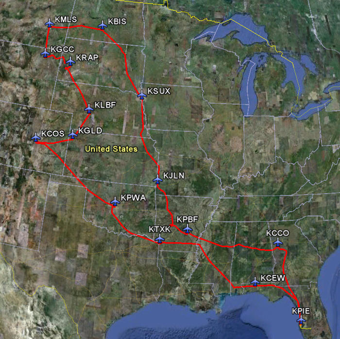
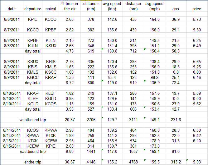
Here is a map of my travels, with the airports that I visited. Below that are some of the particulars of the trip, including over 30 hours in the air, over 4,100 nautical miles (4,768 statute miles) travelled, and 313 gallons of aviation gas purchased at nearly $6.00 each. More notes follow these two pictures.
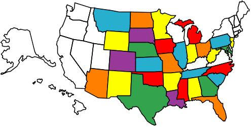
Additional thoughts - This was probably the most ambitious trip I have ever tried, and except for the weather early on, I believe that it was most successful. I wanted to land in as many new states as I could, and I collected 11 new states. Together with the 20 states that I had logged before, this brings my total to 31 states. I missed out on two states this time because of weather. This trip included a total of 15 flight segments, so I am on my way to some good benefits on my airline, like a front seat on every flight, and being able to bypass security. I actually visited 14 new airports, and never once got groped or had to go through the naked-picture machine, and I carried a small knife in my pocket the whole time. My airplane performed without fault, and has now accumulated 1,074 hours. (If I use the actual average speed from this trip to extrapolate total mileage on the airplane, I get over 166,000 statute miles.) Overall, I'm pretty happy with the way the trip worked out, and the places that I have been able to see from the windows of my little airplane. Here is a map of the states that I have visited in my airplane.
I hope you enjoyed reading about my adventure.